

 |
Earth Science Studies of Yucca Mountain |
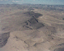
Scientists have made a great deal of progress in their
investigations of the geology of Yucca Mountain and its surrounding
region to determine if the mountain can isolate radioactive
materials be using natural and engineered (man-made) barriers.
Observation of the natural system and data collected since 1978
suggest that the natural system is robust, which is to say that the
geological characteristics of the site appear to be
complimentary--can work together--in their ability to isolate waste.
Further studies are being done in these areas:
| |
|
| |
|
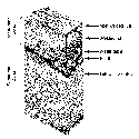
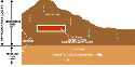
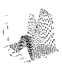
Yucca Mountain has thick layers of volcanic rock called "tuff." If you could take a slice of the mountain, this is how it might look. Scientists have studied themountain to see where faults are and where the saturated zone (the rock underneath the water table) is and have found that the rock quality is as good or better than assumed when scientists first considered a repository at Yucca Mountain. |
|
| |
 |
Geohydrology studies have been focusing on finding out how much water there is in the rock, how it moves through the rock, and how water could affect a repository. Geologic evidence is consistent with models of the site that have been the basis of performance calculation for more than 10 years. However, scientists still must determine the long-term significance of potential fast pathways for water movement. This is important because scientists believe that groundwater is the most likely way radioactive materials could be released from a repository. |
|
| |
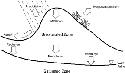 |
Yucca Mountain is in the southern part of the Great Basin, where there is very little rainfall, most of which quickly runs off the surface or evaporates. Approximately 15 centimeters (six inches) of rain falls on Yucca Mountain in a year. Scientists think that only an extremely small fraction of that rain could soak into the ground and actually reach the underground area where the potential repository would be located. But they are conducting studies to determine the exact nature of the movement of water through the rock. Models and data have indicated that water infiltration could be diverted laterally away from the repository level, potentially acting as a buffer against increased rainwater infiltration in the event of future climatic changes. |
|
| |
 |
This makes it possible to put a repository about 300 meters (1,000 feet) underground and still have it be about 240 meters (800 feet) above the water table. Geologists call the rocks and soil above the water table the unsaturated zone. In the unsaturated zone there is relatively little water in the rock and the water there may move very slowly. These factors significantly limit the change of water reaching the corroding waste containers and carrying radioactive material away from a repository. |
|
| |
 |
Project scientists have been studying faults and monitoring earthquakes in the region surrounding Yucca Mountain for more than 10 years. Experience with earthquakes throughout the world has shown that, generall, underground structures can withstand ground motion generated by earthquakes. Tests involving nuclear explosions underground at the Nevada Test Site have shown that underground structures can withstand ground motion greater than that anticipated from earthquakes. |
|
| |
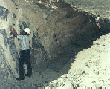 |
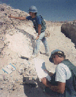
As part of the studies, there are major trenching programs at
Yucca Mountain to study movement of faults during the past two
million years. Geologic study of the deposits found exposed in these
trenches and minerals found in fault zones will provide evidence of
how frequently and how much faults have moved in the past.
Geologists will use dozens of trenches to investigate past movement of faults. The information will be used as part of the seismic hazard analysis of Yucca Mountain. |
|
| |
 |
Yucca Mountain itself was formed millions of years ago by a
series of explosive volcanic eruptions from a special type of
composite volcano called a "caldera." Calderas form when large
volumes of magma erupt rapidly. This removes the underground support
for the volcano, and surface collapses and forms a circular
depression, or caldera. Calderas can range in size from the few
miles to tens of miles across.
The caldera complex, which was the source of Yucca Mountain's welded tuffs, is about 20 miles across and centered about 17 miles north of the mountain. |
|
| |
 |
The massive volcano that formed Yucca Mountain is long extinct, but scientists are studying seven small and long inactive volcanoes in the Yucca Mountain area. They want to determine if one might erupt in the next 10,000 years and if an eruption might affect an underground nuclear repository. By studying layers of soil and rock to learn about past volcanic activities, scientists have been able to make predictions about the future. The probability of a future volcanic eruption directly intersecting a repository at Yucca Mountain is estimated to be about one in 70,000,000 per year, as confirmed by an independent panel of experts. This is in line with earlier estimates by Project scientists. |
|
| |
 |
The seven inactive volcanoes in the Yucca Mountain area are cinder, or scoria, cones. Of the three main types of volcanoes, cinder cones generally have the simplest and weakest eruptions. Scientists estimate that it is unlikely that any of the seven cinder cones will erupt in the next 10,000 years, and extremely unlikely that volcanic activity could directly disrupt the proposed repository location. |
|
| |
 |
Scientists have spent more than a decade at Yucca Mountain
studying whether volcanoes or other geologic events might affect a
repository. They have used samples from drilled holes, trenches, and
geophysical methods in laboratory studies to get the data they need.
These studies of volcanology, seismology, geohydrology and geology have given scientists the information they need to make decisions about the suitability of Yucca Mountain as a spent nuclear fuel and high-level radioactive waste repository. |
| Additional Information: |
![]()
OCRWM | YMP Home | Search |
About |
What's New
| Timeline
Money | Learn | Tour | EIS
| Library
| Links
| Index