

| Scientists are studying Yucca Mountain as a potential geologic repository. Yucca Mountain is located about 100 miles northwest of Las Vegas, NV in a remote area with a very dry climate. The following are drawings and photographs that show Yucca Mountain and some the tests that are currently taking place there. | ||||||||
| How this mountain was made | ||||||||
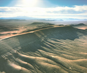 |
Volcanic eruptions, 20 miles away, created Yucca Mountain on surrounding flat land between 7.5 and 15 million years ago. Molten magma spewed into the atmosphere and clouds of ash rolled southward depositing ash, some of it so hot it welded together. Over the ages, layers and layers of volcanic ash compressed and consolidated into a hard rock called tuff. Where the individual layers were laid down, they | |||||||
| bounded imperfectly from layer to layer. The contacts between these layers provide potential pathways for moisture to move. As the rock mass cooled, vertical fracture planes developed that can extend down through several layers. Fault zones that cut across multiple layers of rock also provide a fracture network. Fractures in the mountain provide potential pathways for gases and fluid to move and are a key issue. These pathways will allow radionuclides to move from a repository into the environment, accessible to people, animals, and plants. How quickly this happens is important to public safety and health as defined by the regulatory standards set for Yucca Mountain. | ||||||||
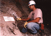 |
Scientists have studied and removed various samples of rock within the Exploratory Studies Facility to determine the properties of fractures found running through the tunnels or alcoves; to characterize the effect of man-made materials on chemical and mineralogical changes in the rock; to study the minerology, petrology (study of the origin of rocks and their composition), and pathways in which water may move downward. | |||||||
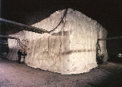
| How radioactive particles might move through rock | ||||||||
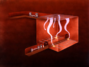 |
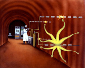
This test simulates how radioactive particles might move through the rock at Yucca Mountain. No radioactive materials are used in this test, only safe chemical tracers. Sprinklers atop a large block of rock distribute water and tracers. Sensors monitor the water and tracer movement at the bottom of the block. If a repository were located here, scientists expect minerals in the rock, called zeolites, to act as a natural barrier, limiting or slowing the movement of radioactive particles. | |||||||
| Rock's response to stress | ||||||||
 |
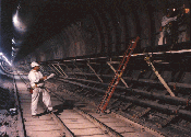
How will Yucca Mountain rock change in response to pressure? Movement, cracking, and other changes could affect the rock's suitability for housing a repository. Excavation creates pressure on the rock. This test, conducted at several locations, measures how Yucca Mountain rock responds. Aluminum jacks set horizontally inside a test alcove apply force | |||||||
| to rock walls. Instruments monitor movement of the walls and compression of the rock beyond the walls. Measuring the squeezing of the rock provides scientists with data they can use to predict how stresses will affect the rock. | ||||||||
 |
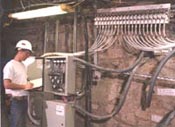
Each week, scientists download information into laptop computers from instruments installed in the steel sets in the tunnel. The data gathered indicates whether the tunnel is expanding or contracting and how competent the overall excavation is. So far, the tunnel formation is very competent. | |||||||
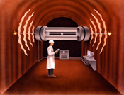
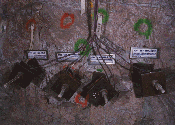
| Water and vapor movement through rock | ||||||||
 |
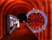
This test of water and vapor movement in the rock uses holes bored in the rock in radial patterns like the spokes on a wheel. Each test includes four boreholes. Gases are pumped into the rock through the injection borehole, and their movement is detected by electronic monitors in three monitor boreholes. Scientists gather data from the monitors and will use the data to predict the rock's ability to transmit fluids, including water. | |||||||
 |
Project scientists inject a mixture of compressed air and a tracer gas (SF-6 or sulphur hexaflouride) into a borehole. After some period of time, they begin to recover the gases from a separate borehole. By knowing the distance between the boreholes and the travel time for the gas, they can determine how fast fluids and gases move through the rock. | |||||||
| Measuring the rock's response to heat | ||||||||
 |
How would the rock at Yucca Mountain respond to heat generated by highly radioactive materials? To find out, scientists simulate the hot, dry environment of a repository using electric heaters instead of waste containers. A series of instruments measure the rock's response to the heat. | |||||||
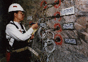 |
This scientist is installing moisture-sensing instrumentation in the rock for the single heater test conducted in the Thermal Test Facility. The equipment she is installing will monitor how much moisture is in the rock and how and where water vapor travels when the rock heats up during the test. | |||||||
 |
In the Thermal Test Facility, another aspect of the single heater test is to measure the impact of high heat upon engineered additions, such as rock bolts, that are used in the tunnel and alcove ground support. By measuring the impact of the heat upon the metal rock bolts, scientists will see whether the engineered ground support can withstand the heat. If the bolts move or fail, it would mean that some other type of ground support might be needed. | |||||||
 |
In the Thermal Test Facility, it took months for the temperature in the single heater test to reach a temperature of 100 degrees Celsius (212 Fahrenheit). The heater test has been going on since August 1996 and was finally turned off in May 1997. Instruments were installed in a large section of rock to measure the thermal-mechanical effects of heat upon the rock and the ground support system. This test is analagous to measuring the heat generated by the nuclear waste canisters and what impact heat would have upon the surrounding rock. | |||||||
|
| ||||||||
| OCRWM | YMP
Home | Search
| About
| What's
New | Timeline
Money | Learn | Tour | EIS | Library | Links | Index | ||||||||