Until modern times, the Gifford Pinchot National Forest was part of an enormous wilderness of forested ridges and valleys, a continuous blanket of green covering this entire corner of Washington. A century of heavy logging along the western slopes of the Cascades in Washington and Oregon has eliminated all but isolated remnants of the once vast temperate rainforests of Douglas-fir, hemlock and western red cedar that Lewis and Clark traveled through on their final approach to the Pacific Ocean. What's at Stake
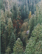
With its tens of thousands of acres of ancient forests, excellent trout fisheries, several pairs of spotted owls, elk foraging areas and diverse habitat for many other kinds of wildlife, the Dark Divide has some of the finest blocks of old-growth forests remaining on the Gifford Pinchot National Forest. These forests - with their huge trees and lush undergrowth - are also contiguous with old growth forests to the north and south, providing an important north-south migration route for wildlife. The lowland drainages provide critical winter range for deer and elk, which would be lost if the area were roaded and logged. Quartz Creek drainage is one of only five valleys in southern Washington below 3,000 feet that remains roadless, and as such is a particularly important remnant of the low elevation virgin forest in this state. Quartz Creek drops steeply from its headwaters on the Dark Divide Ridge, creating 15 waterfalls more than 10 feet high. Clear Creek, which flows through a narrow, deep canyon with plunge pools and fern-lined grottos, is at the center of the National Forest's longest continuous stand of old-growth Douglas-fir forest. It forms a roadless finger attached to the larger Dark Divide Roadless Area. The ThreatsWithin the short span of 30 years, logging has cut the Dark Divide roadless area in half. Many miles of trails have been lost, and those remaining are often fragmented by roads. What does remain is critical for wildlife and recreational values, especially since roading and logging have eliminated much of the once extensive forest in the Northwest. Without protection, logging will further fragment key ancient forests of the Dark Divide. The SolutionsDespite recent logging, a network of 18 linked trails provides 90 miles of hiking and horseback riding opportunities. The Dark Divide is also popular with hunters in the fall. As the use of nearby wilderness areas like Goat Rocks and Indian Heaven become ever greater due to expanding public demand for a wilderness experience, large roadless areas like the Dark Divide will become more and more valuable for the recreational opportunities they can provide. The Dark Divide roadless area, with its wide network of trails, wildlife, streams, waterfalls and outstanding views, is a truly unique and special area deserving of protection from further logging activities. This land of sharp ridges and forested slopes was the major western Washington area that was not designated as wilderness in the passage of the Washington Wilderness Act in 1984. In order to protect the roadless quality of this area - as well as what still remains of the Pacific Northwest's cathedral-like ancient forests of Lewis and Clark's day - the time has come for the Dark Divide to be protected as wilderness. In addition, the Forest Service has recommended the adjacent Lewis River for Wild and Scenic River status. The Sierra Club strongly supports designation of this river. Mt Adams photo by Kurt Wieland
| ||||||||
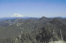

 The Dark Divide, with approximately 57,000 acres of intact
roadless land, represents a unique topographic region unduplicated by any
other protected roadless area in Washington's southern Cascades. The area
is mostly mountainous with steep, forested slopes of old-growth and
younger virgin forests. Rugged, open, mile-high ridges are topped by rock
spires and glacial cirques. The ridgetops are bare or support sparse
alpine vegetation. Abundant streams and waterfalls provide refreshing
respites to hikers on hot summer days. Several steep river valleys, the
major ones being Quartz Creek and upper Clear Creek, cascade into the
forested lowlands below. The southern portion of the roadless area drains
into the Lewis River, which was named for Meriwether Lewis.
The Dark Divide, with approximately 57,000 acres of intact
roadless land, represents a unique topographic region unduplicated by any
other protected roadless area in Washington's southern Cascades. The area
is mostly mountainous with steep, forested slopes of old-growth and
younger virgin forests. Rugged, open, mile-high ridges are topped by rock
spires and glacial cirques. The ridgetops are bare or support sparse
alpine vegetation. Abundant streams and waterfalls provide refreshing
respites to hikers on hot summer days. Several steep river valleys, the
major ones being Quartz Creek and upper Clear Creek, cascade into the
forested lowlands below. The southern portion of the roadless area drains
into the Lewis River, which was named for Meriwether Lewis.